NYC Waterfront Public Access Study
How well connected are New Yorkers to the waterfront?
Study Purpose
New York City’s waterfront and waterways are vital resources that provide New Yorkers with open space for recreation, relaxation, and reflection. The Department of City Planning (DCP) conducted the Waterfront Public Access Study to better understand New Yorkers’ access to open space along NYC’s 520 miles of waterfront and to support the NYC Comprehensive Waterfront Plan released in December 2021.
In addition to informing the Comprehensive Waterfront Plan’s Waterfront Public Access goals, the study findings will be used by DCP and our sister agencies to support forthcoming waterfront zoning studies to expand waterfront public access.
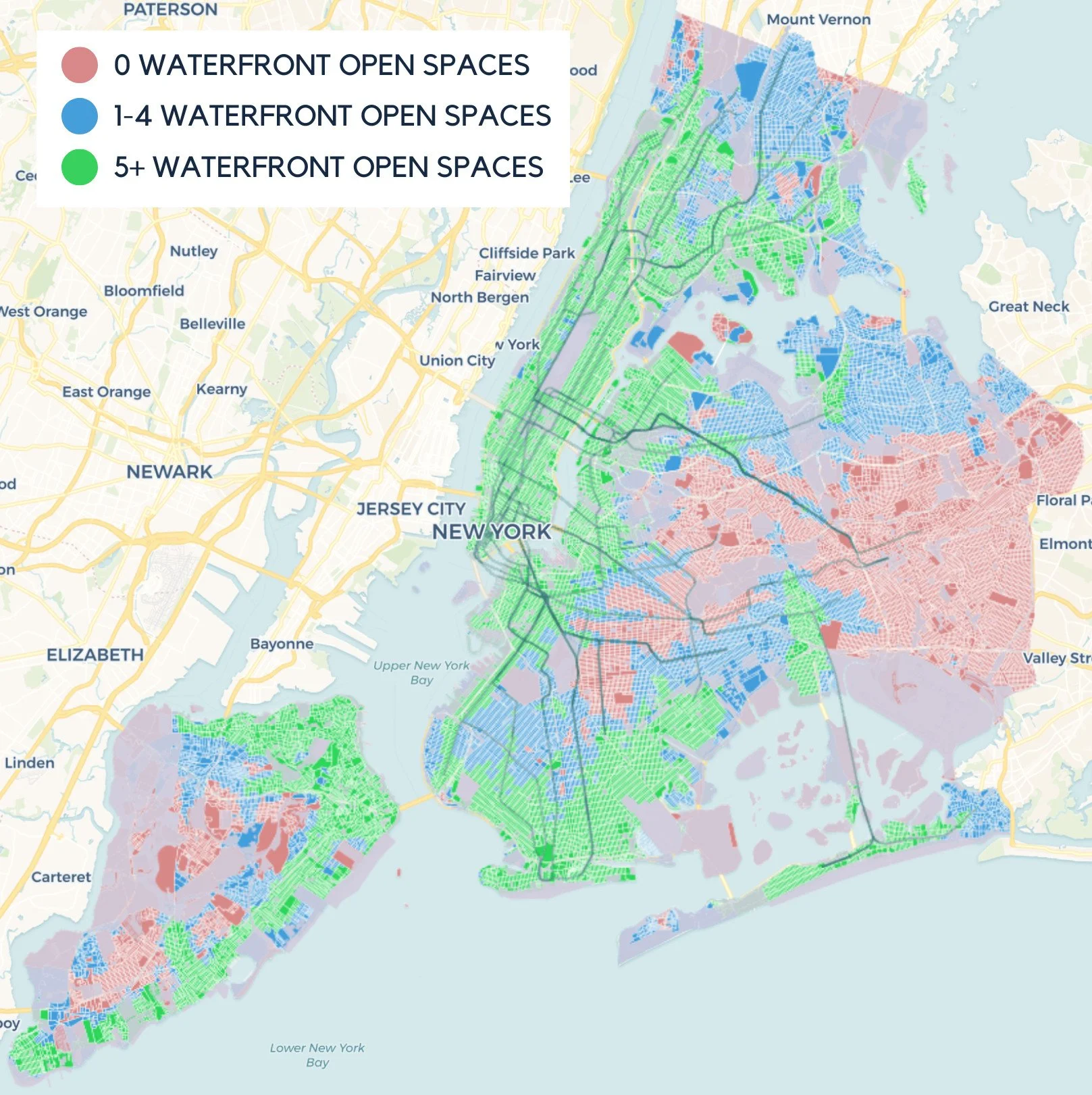
Key Findings: Waterfront Community Connectivity
2.9 Million
New Yorkers live within a half-mile walk of the waterfront.

7 in 10
Waterfront residents have access to a waterfront park or open space within walking distance of their home — that’s around 2 million New Yorkers.
But 3 in 10 waterfront residents, which is more than 800,000 New Yorkers, lack direct access to a waterfront open space despite living just a short walk from the water.
Waterfront Public Access by Borough
90% of Manhattan residents living within a half- mile of the waterfront have direct access to a waterfront open space, but fewer than half of Bronx residents within a half-mile of the waterfront can access it.

Waterfront public access varies by race and ethnicity, income, and borough. Less wealthy waterfront communities and communities of color are less likely to have access to waterfront open space.
Key Findings: Citywide Connectivity to Waterfront Destinations Via Public Transit
Our transit system plays an important role in connecting inland New Yorkers to the waterfront.
About 80% of New Yorkers have access to at least one waterfront public open space and/or public swimming beach within 30 minutes of their home by public transportation, with the figure rising to 99% of New Yorkers within 60 minutes.
The largest gaps are in Southeast Queens where transit service and direct access to a NYC waterfront open space are limited.
Waterfront open space access by census block within a 30-minute transit ride.
Expanding Waterfront Public Access: Next Steps for the Department of City Planning
Identify opportunities to expand applicability of waterfront public access zoning requirements as waterfront uses continue to evolve.
Explore opportunities to improve design standards for waterfront public access areas created through zoning.
In partnership with citywide agencies, continue working to develop a waterfront public access framework that addresses systemic access gaps and prioritizes investments in underserved communities.
Engage in citywide efforts to identify City-owned waterfront sites and facilities that can support additional public access.
Alongside agency and community partners, study ways to connect and unify public spaces along the water’s edge and strengthen connections with upland communities.
Support completion of planned waterfront greenway improvements that leverage the unique opportunities and community needs along the waterfront.
Explore the Waterfront Public Access Study or download this summary as a PDF